About this blog

'Going Spatial' is my personal blog, the views on this site are entirely my own and should in no way be attributed to anyone else or as the opinion of any organisation.

My tweets on GIS, Humanitarian, Tech, Games and Randomness

Monday 24 December 2012

Public versus Private cloud: AWS perspective and moving more towards Linux

Amazon Web Services, the world's largest public cloud provider slammed into private cloud providers during AWS Re:Invent conference.

AWS also lowers the cost of S3 by 25% and now is moving into the data warehousing market with RedShift, read it here

I have been a happy user of AWS for the last two years and while there are some issues (mainly the quite difficult to understand billing) - the service has been superb over this time. I can only assume that the per hourly costs will continue to drop down.

Ah Linux, long been a favour distribution of mine as it appealed to the inner geek of me but in the commercial world; it had only a small impact. However, 2013 may now change this and there are plans to roll out Linux (mainly CentOS) onto our build, stage and possibly live environments. This is exciting and scary at the same time. However, I have to admit that the stability of Linux and the ability to reuse a lot of older kit very effectively has turned a lot of my more skeptical colleagues around.

Add caption
So many lovely maps......
A colleague of mine pointed me towards a silver-light application titled 'Pivor for ArcGIS Online' - a very unassuming name but with the 1000s of webmaps (http://storymaps.esri.com/home/) being published and made available, Pivot allows you to find these maps in a nifty one-stop-shop type of application. As a starting point, click this link and type in 'rivers' or 'hurricane' and see what pops out, alternatively click on the graphics above and explore.

Finally, Santa has come to town: check out the Santa Dashboard by clicking on the picture. It's an old but a great idea and there's some very nice images there...

Santa's coming to town.....


http://storymaps.esri.com/stories/2012/santa-dashboard/

Have a great christmas - and yes, the world hasn't ended.

Wednesday 12 December 2012

12:12:12:12:12

A special day!

Just had to do it.

A very significant date and the BBC news has articles of people marrying on this day and other bits. A random post but I thought, why not join the bandwagon?

On a slightly more serious note: Australian police warn the public not to use Apple Maps (since fixed)...

Normal service will now resume!

Tuesday 11 December 2012

Puzzle Maps?

Europe, but not quite as you know it...
This just caught me eye during my internet wanders and yes, it's another Esri Story Map but it came to me in a roundabout way. It illustrates very nicely how interactivity can really enhance a visually pleasing map. I love maps and quizzes and having both in one application is very cool.

Anyway, click on this link (or the image) and see if you can beat my time of 4minutes 28 seconds. It is harder than it looks! My last 20 odd seconds was spent trying to fit the missing shapes into all remaining countries!

This also caught my eye: http://hpc.vcea.net/ - old photographs from China, should be ripe for it to be geo-coded (as much as possible?) - so off to ArcGIS Online I go. Here's my first pass: http://bit.ly/VPTHiT

Wednesday 5 December 2012

Treasure Hunting Story Maps

and get some treasure.....!
I love quizzes, especially geography ones. That's why when it comes to pub quizes and trivial pursuit, Geography related subjects are my first choice.

Here's a wonderful story map / treasure hunt from Esri Inc.

http://storymaps.esri.com/stories/2012/treasure-hunt-cities/

Friday 30 November 2012

What has it been like after 12+ months?

My company has made a fundamental shift towards Cloud computing and specifically towards Amazon Web Services (AWS) in the last 12 months.
I think this is a picture of the servers for Facebook?

Quoting the wiki (it’s always good to start with someone’s quote!):

 Cloud computing is the delivery of computing as a service rather than a product, whereby shared resources, software, and information are provided to computers and other devices as a utility (like the electricity grid) over a network, typically the Internet.

Why did we do it? At the technical level it was always something that we wanted to do but like all projects it needs strategic buy-in. The potential cost savings (as published in the media) as well as the flexible nature of the cloud meant that it was foolish not to try the cloud if only to compare it with the environment of ‘traditional’ hosting. At a strategic level, our parent company had already migrated some of their main-line hosting applications to the cloud via AWS so there was a path already set out (albeit with differences in application and customers).

So the process of migrating to the cloud took a number of distinctive steps.

1. Planning
2. Test Deployment
3. Parallel Running
4. Go Live
5. Update documentation and processes

Tuesday 27 November 2012

Elite - the latest version now on KickStarter!

This is a service interruption:
Just wanted to share and spread the news that the latest installment of Elite is coming along providing the kickstarter campaign reaches its goal of $1.25 million, it's 1/3 of the way and I hope it makes it with another 38 days to go.

http://www.kickstarter.com/projects/1461411552/elite-dangerous


I started my love affair with epic space games with Elite and see its echoes in Frontier and Eve Online and other similar space based 'operatic' games.

All power to them, I hope it works!

Normal service and broadcasting will now resume.

Friday 23 November 2012

Windows 2012 now available in AWS

Windows 2012 AMIs now available under Amazon Web Services

Read it here.

This is very exciting and I will be using my micro instance allocation (free) to test it out; of course I am unsure whether Windows 2012 will even start up properly with so little resources but that's part of the test I think. Once this works, I will slap on all sorts of GIS related software and put it through its paces.


Yesterday, I went over to the Microsoft site to get a bit more information on Windows 2012 and for me the main takeaway points is that 2012 has cloud and virtualisation built into the software. I think one can 'burst' one's network into Microsoft Azure to take advantage of extra capacity on demand. This is quite cool and while possible with today's public/private cloud architectures, it isn't easy and requires configuration and expertise that is outside many organisation's capabilities.

New Relic, New Monitoring
A nice dashboard, but I removed the server names off it...

Meanwhile, I have been playing about with the real time application monitoring service from New Relic (www.newrelic.com) and I have to say, I am very impressed with the tools and dashboards available as well as the intuititve interface. Their support so far has been excellent too. Based on this, we are hopeful that their prices are reasonable and that I can get sign-off. It's got the thumbs up from our ops and developers; two groups that frequently have very different requirements.


We definitely like it!

I should get a t-shirt too.

Tuesday 20 November 2012

What am I reading right now?

That's not really me there...

Here's what I am reading right now, gives you all an idea on what I need to know...


How to create your own self-signed certificate
http://www.akadia.com/services/ssh_test_certificate.html


Windows on Amazon EC2 Security
http://aws.amazon.com/articles/1767


AWS ELB SSL limitations
http://swearingatcomputers.blogspot.co.uk/2011/04/aws-load-balancer-ssl-limitations.html

Accelerating Map Caches under ArcGIS Server 10.1
http://blogs.esri.com/esri/arcgis/2012/11/19/accelerating-map-cache-creation/

Load Balancing FAQs
http://www.loadbalancing.org/#SSL_Termination
 

Thursday 25 October 2012

Very cool story map from the IUCN Red List

A wonderful story map


Maps can help people tell a story in a far more convincing and compelling fashion than verse and prose alone. Seeing patterns, lines and shapes and how they relate to each adds an extra layer of information that cannot be easily done without a map.


I love Story Maps, and one very eye-catching one is from the IUCN Red List of endangered species.

Here is the link.

Grasshopper
I found it very intuitive, visually pleasing and packed full of relevant and useful information. You can navigate either by selecting the endangered animals icon or through a pick list. The slide bar at the bottom allows you to filter based on the eight categories available ranging from 'Not Evaluated' to Extinct. Simple and easy to use. Hovering the mouse over any of the icons brings a simple tool-tip with a photo and name of the endangered animal. Click on the icon itself and an informative pop-out window with more information is presented including a link to the full assessment information held on the IUCN database. Useful information more or less at one's fingertips packaged up in a smooth and easy to use system.

You know what? I never knew that...

Friday 19 October 2012

Velocity 2012

(Warning: Long Post. TL;DR summary will come soon! I did make a mind-map for each session - scroll right to the bottom of the post to get them)


I attended the Velocity 2012 Conference on the 2nd October. I just signed up for the tuesday tutorials: x4 90-minute topics due to time constraints and workload. Some of my colleagues attended the entire 3-day event. However, I found that the 90-minute sessions had the right amount of depth and breadth to keep me interested.

This is my first Velocity conference, a gathering aimed squarely at the web performance and operations crowd: absolutely perfect for my current job role and my team. Wonder why I never heard of it until now?

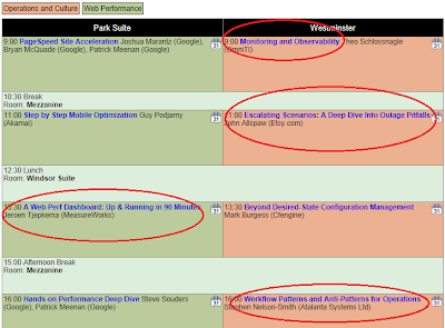
Here's the schedule list.

Velocity 2012 - Tue
My list for the day.


Monitoring and Observability ( Theo Schlossnagle from OMNITI)
This session started with the simple facts that you can’t fix what you can’t see and you can’t improve what you can’t measure. The difference of the two terms was also important: observation is the passive observation of data providing trends and baseline; while monitoring is the direct observation of failure in real-time.

Tuesday 9 October 2012

ArcGIS Online Monthly Cost Calculator

The pricing for Esri's ArcGIS Online is now available here. ArcGIS Online has published it's monthly cost calculator here to help users estimate how much a set of services will cost them. ArcGIS online is a subscription service that allows customers to pay-as-you-go to access maps, services and applications. They are paid for using the Esri Service Credit, which I think it needs a currency symbol and the ISO4217 code - 'ESC' is free if anyone is interested. They are sold in blocks of 1000 credits and each unused credit expires after two years.  The price per Esri credit is dependent on the country the user is in and therefore pricing information is in the local currency.

Eventually, I can see one being able to use this currency to pay for the use of Esri software licenses and even stuff from Esri Press and their store!

That should be fun but we're still some distance from there.

From my own services and projects, it appears the estimating tool tells me that I need 38,290 esri credits (ESC) a year. Now where's the GBP to ESC converter?

Thursday 13 September 2012

Story telling with maps


Using maps to tell a story is something that is quite natural; whenever I describe either a story or an idea or discuss anything with a geographic content, I also try and use a diagram (via doodling) or fire up the web and grab a map.


Esri Inc has a nice site, that collects a bunch of narrative driven maps into one location. It's called storytelling maps and I think it is great idea. I love the story map about the titanic and her passengers.

While diving around the various websites is great fun, I did come across a rather sobering tale of when this journey and your identity is rudely interrupted. Here's the tale of someone who got hacked and lost most (if not all) of his virtual identity.

Naturally, I went over to Google and quickly initiated their two-factor security which has stopped my email client from working and other bits but oh well. Nothing like security. Am also reviewing my own household security and in the cold light of day, there are a few things that I now realise that I should change, immediately.

I know it's a balance between convenience and annoyance but right now, I am in the pull-up-the-drawbridge-type-of-thinking.

Also, am going to do a thorough audit of our own work's security, just to satisfy myself that it is indeed, as water-tight as can be.

Tuesday 26 June 2012

Content and all that

ArcGIS and the superlatives...
As per my last post, I had to double (actually triple) my output to ensure that I could generate enough interesting and useful content. This blog is as much a reminder for myself on new ideas, technologies and products as it is a soap box for my occasional rants. However, I have managed to work out a more sensible approach to writing pieces for it, so that I avoid repeating myself yet keep it interesting.

So what has been going on in my bit of the cloud and all things GIS? ArcGIS 10.1 is now out, offically. After much fan fare, the latest and greatest version of Esri Inc's GIS system, ArcGIS is now commercially available. The superlatives for this release are legion but suffice it to say,  it is the most significant release of this software in the last 10 years in my opinion. Where to start? 64- bit support for the server, linux support, postgreSQL support, performance improvements, rewritten cache engine, ArcGIS Runtime and of course, all things now point to online. This means that Esri Inc has firmly laid out its vision for the future and for ArcGIS, it is online and about sharing, collaboration and ease of use through a subscription service. Only a matter of time before you can pay to use ArcGIS on an hourly basis. 
 
There's also the relevant 10.1 AWS AMI and I am very excited to see the Ubuntu version this time, will be using this as soon as able as I love Ubuntu (and it's spin-off Mint) and run it at home.

About time too!
I am definitely looking forward to this Ubuntu version and I am inspired to try it out on my own local virtual machine too!

With the Queen's jubilee, one of my colleagues put together this interactive, intelligent map  and it was featured in various national and international media outlets.

Can you find your nearest beacon?
The interest generated by this map was huge and had millions of hits; since the site was hosted through Amazon Web Services - the server it was on scaled up automatically in response to the extra load. A beautiful model of on-demand, subscription services.

Friday 27 January 2012

Doubling my output?

Happy New Year all - my blogging output has been redirected to adding content to the company Blog since November 2011 and I didn't want to cross-post too much. Certainly, for the company blog I need to post with my company-hat on with the content being checked, edited and possibly changed as required.

Main issue for me is that my content needs to either double so that I can continue to feed both blogs or one grows at the expense of the other. I actually have a load of subjects and ideas but I now need to find the time for it too!

Anyway, I think I have come to a workable solution. More later!

Oh, here's an oldie but goldie from Salesforce.com which I had stumbled upon during a training session I had.